Geography of Iceland
| Native name: Ísland Sobriquet: Land of Fire and Ice |
|
|---|---|
 Map of Iceland |
|
 |
|
| Geography | |
| Location | Atlantic Ocean |
| Area | 103,000 km2 (39,800 sq mi) |
| Area rank | 18th |
| Coastline | 4,988 km (3,099.4 mi) |
| Highest elevation | 2,110 m (6,920 ft) |
| Highest point | Hvannadalshnúkur |
| Country | |
|
Iceland
|
|
| Largest city | Reykjavík (pop. 118,861) |
| Demographics | |
| Population | 316,252 (as of 2008) |
| Density | 3.1 /km2 (8 /sq mi) |
| Ethnic groups | Icelanders |
Iceland is the second-largest island in Europe. The island is located east of Greenland and immediately south of the Arctic Circle, atop the divergent boundary of the Mid-Atlantic Ridge in the North Atlantic Ocean. It lies about 4,200 km (2,610 mi) from New York City and 860 km (534 mi) from Scotland.
Iceland has extensive volcanic and geothermal activity. The rift associated with the Mid-Atlantic Ridge, which marks the division between the European and North American tectonic plates, runs across Iceland from the southwest to the northeast. This geographic feature is prominent at the Þingvellir National Park, where the promontory creates an extraordinary natural amphitheatre. The site was the home of Iceland's parliament, the Alþing, which was first convened in 930.
About half of Iceland's land area, which is of recent volcanic origin, consists of a mountainous lava desert (highest elevation 2,119 m (6,952 ft) above sea level) and other wasteland. Eleven percent is covered by three large glaciers:
- Vatnajökull (8300 km²)
- Langjökull (953 km²)
- Hofsjökull (925 km²)
and several smaller ones:
- Mýrdalsjökull (695 km²)
- Drangajökull (199 km²)
- Eyjafjallajökull (107 km²)
- Snæfellsjökull.
Twenty percent of the land is used for grazing, and only 1% is cultivated. An ambitious reforestation program is under way. Fossilized tree pollen and descriptions by the early settlers indicate that prior to human settlement in the 8th-10th century, trees covered about 30-40% of the island. Today, however, there are only small patches of the original birch forests left, the most prominent are Hallormsstaðaskógur and Vaglaskógur.
The inhabited areas are on the coast, particularly in the southwest; the central highlands are totally uninhabited.
Because of the Gulf Stream's moderating influence, the climate is characterized by damp, cool summers and relatively mild but windy winters. In Reykjavík, the average temperature is 11 °C (51.8 °F) in July and 0 °C (32 °F) in January (Koppen: Cfc).
Contents |
Statistics
- Geographic coordinates
- Northern Europe (for cultural and historical reasons it is not considered to be a part of North America), between the Greenland Sea and the North Atlantic Ocean, northwest of the British Isles.
- North: Rifstangi, 66°32′3" N (Kolbeinsey, 67°08,9 N)
- South: Kötlutangi, 63°23′6" N (Surtsey, 63°17,7 N)
- West: Bjargtangar, 24°32′1" W
- East: Gerpir, 13°29′6" W (Hvalbakur, 13°16,6 W)
- Map references
- Arctic Region
- Area
-
- Total: 103,125 km²
- Land: 100,329 km²
- Water: 2,796 km²
- Area—comparative
- Slightly smaller than Kentucky; about half the size of Great Britain; slightly larger than Hokkaidō
- Land boundaries
- 0 km
- Coastline
- 4,988 km
- Maritime claims
-
- Continental shelf: 200 nmi (370.4 km; 230.2 mi) or to the edge of the continental margin
- Exclusive economic zone: 200 nmi (370.4 km; 230.2 mi)
- Territorial sea: 12 nmi (22.2 km; 13.8 mi)
- Climate
- Temperate; moderated by North Atlantic Current; mild, windy winters; cool summers, damp in the South and West
- Terrain
- Mostly plateau interspersed with mountain peaks, ice fields; coast deeply indented by bays and fjords
- Elevation extremes
-
- Lowest point: Jökulsárlón Lagoon: -146 m, Atlantic Ocean 0 m
- Highest point: Hvannadalshnúkur 2,110 m
- Natural resources
- Fish, hydropower, geothermal power.
- Land use
-
- Arable land: 0.07%
- Permanent crops: 0%
- Permanent pastures: 23%
- Forests and woodland: 1%
- Other: 76% (1993 est.)
- Irrigated land
- NA
- Natural hazards
- Earthquakes, volcanic activity, avalanches, and glacial lake outburst flooding (or jökulhlaups)
- Environment—current issues
- Water pollution from fertilizer runoff; inadequate wastewater treatment
- Environment—international agreements
-
- Party to: Air Pollution, Biodiversity, Climate Change, Desertification, Endangered Species, Hazardous Wastes, Law of the Sea, Marine Dumping, Nuclear Test Ban, Ozone Layer Protection, Ship Pollution (MARPOL 73/78), Wetlands, Whaling
- Signed, but not ratified: Air Pollution-Persistent Organic Pollutants, Environmental Modification, Marine Life Conservation
- Geography—note
- Strategic location between Greenland and Europe; westernmost European country; more land covered by glaciers than in all of continental Europe
Maps and Images
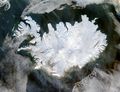 True colour satellite image of Iceland in winter |
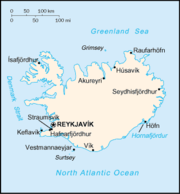
 Map of Iceland showing major towns and geographical features |
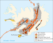 Active volcanic areas and systems in Iceland |
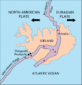 Map showing the Mid-Atlantic Ridge splitting Iceland and separating the North American and Eurasian Plates |
 Ridge between the tectonic plates of Eurasia and North America |
 Iceland is rich in sulfur deposits. |
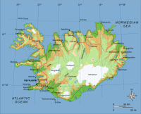
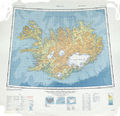 Topographic map of Iceland |
See also
|
|
External links
|
||||||||||||||||||||||||||||||||||||||||||||||||||||||||
|
||||||||||||||